
37.5 dunams seized at Beitunia to enlarge an army site
The land falls in basins where registration was never completed, and possession of it passes to an Israeli defence ministry official for 60 days.
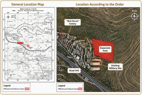
The Colonization and Wall Resistance Commission said on Sunday that Israel had issued a military order taking 37.481 dunams — about 9.3 acres — belonging to the city of Beitunia, west of Ramallah in the occupied West Bank, in order to enlarge a military site already standing on the city's land.
The order carries the number T/101/26 and covers several separate parcels together with the roads that run between them. Maps attached to it show the whole of that area as one continuous block joined to the existing site, which sits beside the Israeli settlement of Beit Horon and close to Route 443.
Two features of the ground itself appear in the paperwork. The parcels lie in Basins 30 and 36, where the registration of title was never finished, and possession of them passes for 60 days from the date of signature to the Israeli defence ministry official who handles such matters. Owners and others affected have seven days from a field inspection in which to lodge objections, and may instead ask for usage fees or for compensation.
The commission was careful about what an order of this kind does and does not do. It does not move a name on a deed. What it takes away are the two things that ownership consists of in practice — the right to hold the land and the right to work it — and for as long as the order runs, the ground sits under direct military control while its owners keep a title that entitles them to nothing on the spot.
Beitunia's 37 dunams are one line in a monthly tally. Across the occupied West Bank in July, the commission counted 31 seizure orders covering some 831 dunams, roughly 115 of them inside the Ramallah and al-Bireh governorate.
What the ground is wanted for is set out in the order rather than guessed at: the site being enlarged exists to protect a settlement and to secure the area around it. Every order of this kind therefore gives the settlement it serves a second outline. There is the built-up part that appears on a map, and then there is the military perimeter held to defend it, which has to be cut out of land belonging to somebody else.